Geolocate

Eboli topographic map

Click on the map to display elevation.

About this map

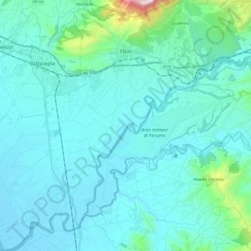
Name: Eboli topographic map, elevation, terrain.

Location: Eboli, Salerno, Campania, 84025, Italy (40.48108 14.90604 40.65208 15.09855)

Average elevation: 318 ft

Minimum elevation: -7 ft

Maximum elevation: 3,097 ft

Other topographic maps

Click on a map to view its topography, its elevation and its terrain.

Montepertuso

Italy > Campania > Salerno > Arienzo

Average elevation: 1,493 ft

Valico di Chiunzi

Italy > Campania > Salerno

Average elevation: 1,680 ft

Persano

Italy > Campania > Salerno > Serre

Average elevation: 82 ft

Sicilì

Italy > Campania > Salerno

Average elevation: 748 ft

Il Gallo Lungo

Italy > Campania > Salerno > Positano

Average elevation: 0 ft

M.Licosa

Italy > Campania > Salerno

Average elevation: 374 ft

Gear up for your next adventure:

🌡️Portable Weather Meter - Track weather conditions on the trail
🎁Geography Themed Gifts - Unique gift ideas for map lovers and geography enthusiasts
💧Water Filtration Bottles - Safely drink from streams and lakes while exploring
🪶Trail Camera - Capture wildlife on your hikes
🚑Emergency Bivvies - Heat-reflective sleeping bags for survival situations

As an Amazon Associate, this site earns from qualifying purchases at no extra cost to you.