Geolocate

Tranent topographic map

Interactive map

Click on the map to display elevation.

About this map

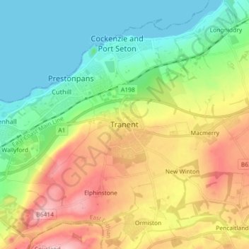
Name: Tranent topographic map, elevation, terrain.

Location: Tranent, East Lothian, Scotland, EH33 1AF, United Kingdom (55.90450 -2.99349 55.98450 -2.91349)

Average elevation: 203 ft

Minimum elevation: 0 ft

Maximum elevation: 531 ft

Other topographic maps

Click on a map to view its topography, its elevation and its terrain.

Musselburgh

United Kingdom > Scotland > East Lothian

Musselburgh, East Lothian, Scotland, EH21 7DX, United Kingdom

Average elevation: 105 ft

Ormiston

United Kingdom > Scotland > East Lothian > Ormiston

Ormiston, East Lothian, Scotland, EH35 5HN, United Kingdom

Average elevation: 335 ft

Dunbar

United Kingdom > Scotland > East Lothian

Dunbar, East Lothian, Scotland, EH42 1ER, United Kingdom

Average elevation: 79 ft