
Make a donation
Gear up for your next adventure:
As an Amazon Associate, this site earns from qualifying purchases at no extra cost to you.
Lambzig topographic map
Click on the map to display elevation.
Make a donation
Gear up for your next adventure:
As an Amazon Associate, this site earns from qualifying purchases at no extra cost to you.
Lambzig
Lambzig liegt im Osten des Gebiets der Stadt Netzschkau. Der Ort befindet sich im Osten des Naturraumes Vogtland im sächsischen Teil des historischen Vogtlands. Lambzig liegt auf einem Höhenrücken, der im Westen vom Limbach und im Osten von der Göltzsch begrenzt wird.
Make a donation
Gear up for your next adventure:
As an Amazon Associate, this site earns from qualifying purchases at no extra cost to you.
About this map
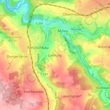
Name: Lambzig topographic map, elevation, terrain.
Average elevation: 1,237 ft
Minimum elevation: 915 ft
Maximum elevation: 1,516 ft
Make a donation
Gear up for your next adventure:
As an Amazon Associate, this site earns from qualifying purchases at no extra cost to you.
Other topographic maps
Click on a map to view its topography, its elevation and its terrain.