Geolocate

Bulwer topographic map

Click on the map to display elevation.

About this map

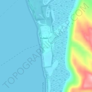
Name: Bulwer topographic map, elevation, terrain.

Location: Bulwer, City of Brisbane, Queensland, Australia (-27.08526 153.36690 -27.07281 153.37162)

Average elevation: 75 ft

Minimum elevation: 0 ft

Maximum elevation: 502 ft

Other topographic maps

Click on a map to view its topography, its elevation and its terrain.

Bulimba Creek

Australia > Queensland > City of Brisbane

Average elevation: 36 ft

Tangalooma

Australia > Queensland > City of Brisbane

Average elevation: 135 ft

Enoggera Hill

Australia > Queensland > City of Brisbane

Average elevation: 374 ft

Toohey Mountain

Australia > Queensland > City of Brisbane

Average elevation: 174 ft

Enoggera Dam

Australia > Queensland > City of Brisbane

Average elevation: 295 ft

Wilcannia Park

Australia > Queensland > City of Brisbane

Average elevation: 249 ft

Blunder Creek

Australia > Queensland > City of Brisbane

Average elevation: 85 ft

Tangalooma

Australia > Queensland > City of Brisbane

Average elevation: 135 ft

Timberland Park

Australia > Queensland > City of Brisbane

Average elevation: 121 ft

Deepwater Bend

Australia > Queensland > City of Brisbane

Average elevation: 16 ft

Gear up for your next adventure:

🛶Inflatable Kayak - Portable kayak for rivers, lakes, and expeditions
📱Solar Portable Charger - Solar power bank for charging devices off‑grid
Backpacking Tents - Weight-optimized shelters for multi-day topographic surveys
🚁Photography Drones - Capture stunning aerial views of landforms and topography
🪑Ultralight Camp Chairs - Portable seating for resting after a long day of mapping

As an Amazon Associate, this site earns from qualifying purchases at no extra cost to you.