
Make a donation
Gear up for your next adventure:
As an Amazon Associate, this site earns from qualifying purchases at no extra cost to you.
Sisian topographic map
Click on the map to display elevation.
Make a donation
Gear up for your next adventure:
As an Amazon Associate, this site earns from qualifying purchases at no extra cost to you.
Sisian
Sisian (Armenian: Սիսիան [sisˈjɑn]) is a town and the centre of the Sisian Municipality of the Syunik Province in southern Armenia. It is located on both banks of the Vorotan River, at an altitude of 1600 m above sea level, 6 km south of the Yerevan-Meghri highway, at a road distance of 217 km southeast of the capital Yerevan, and 115 km north of the provincial capital Kapan.
Make a donation
Gear up for your next adventure:
As an Amazon Associate, this site earns from qualifying purchases at no extra cost to you.
About this map
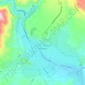
Name: Sisian topographic map, elevation, terrain.
Location: Sisian, Sisian Community, Syunik Province, Armenia (39.50896 45.99700 39.54338 46.04916)
Average elevation: 5,387 ft
Minimum elevation: 5,105 ft
Maximum elevation: 6,240 ft
Make a donation
Gear up for your next adventure:
As an Amazon Associate, this site earns from qualifying purchases at no extra cost to you.
Other topographic maps
Click on a map to view its topography, its elevation and its terrain.
Goris
Goris is situated in the valley of Goris River, also known as Vararak River. The valley is surrounded with the Zangezur Mountains. The town has an average elevation of 1,385 metres above sea level. The surrounding mountains are famous for their medieval cave-dwellings carved out of the soft rock in the…
Average elevation: 4,964 ft