Make a donation
Gear up for your next adventure:
As an Amazon Associate, this site earns from qualifying purchases at no extra cost to you.
Drinkstone topographic map
Click on the map to display elevation.
Make a donation
Gear up for your next adventure:
As an Amazon Associate, this site earns from qualifying purchases at no extra cost to you.
About this map
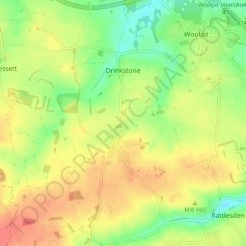
Name: Drinkstone topographic map, elevation, terrain.
Location: Drinkstone, Mid Suffolk, Suffolk, England, United Kingdom (52.18826 0.83601 52.23063 0.88563)
Average elevation: 223 ft
Minimum elevation: 135 ft
Maximum elevation: 299 ft
Make a donation
Gear up for your next adventure:
As an Amazon Associate, this site earns from qualifying purchases at no extra cost to you.
Other topographic maps
Click on a map to view its topography, its elevation and its terrain.
Stanway Green
United Kingdom > England > Suffolk > Mid Suffolk > Worlingworth
Average elevation: 190 ft
Make a donation
Gear up for your next adventure:
As an Amazon Associate, this site earns from qualifying purchases at no extra cost to you.
Make a donation
Gear up for your next adventure:
As an Amazon Associate, this site earns from qualifying purchases at no extra cost to you.
Make a donation
Gear up for your next adventure:
As an Amazon Associate, this site earns from qualifying purchases at no extra cost to you.
Thorpe Street
United Kingdom > England > Suffolk > Mid Suffolk > Hinderclay > Thorpe Street
Average elevation: 118 ft
Make a donation
Gear up for your next adventure:
As an Amazon Associate, this site earns from qualifying purchases at no extra cost to you.
Withersdale Street
United Kingdom > England > Suffolk > Mid Suffolk > Mendham > Withersdale Street
Average elevation: 125 ft
Make a donation
Gear up for your next adventure:
As an Amazon Associate, this site earns from qualifying purchases at no extra cost to you.
