Geolocate

Dunfermline topographic map

Click on the map to display elevation.

About this map

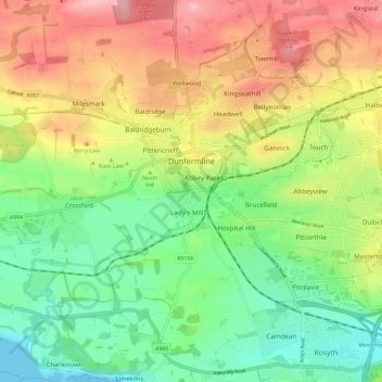
Name: Dunfermline topographic map, elevation, terrain.

Location: Dunfermline, Fife, Scotland, United Kingdom (56.04430 -3.50324 56.08817 -3.38688)

Average elevation: 262 ft

Minimum elevation: 0 ft

Maximum elevation: 627 ft

Gear up for your next adventure:

🪵Folding Camp Saw - Compact saw for wood and campsite work
🧯Portable Fire Pit - Compact fire pit for camping spots
🔋Rechargeable Batteries - Power up your outdoor devices
📌Outdoor GPS Map App - Apps and devices for digital topographic navigation
🎁Geography Themed Gifts - Unique gift ideas for map lovers and geography enthusiasts

As an Amazon Associate, this site earns from qualifying purchases at no extra cost to you.