Geolocate

Liethe topographic map

Click on the map to display elevation.

About this map

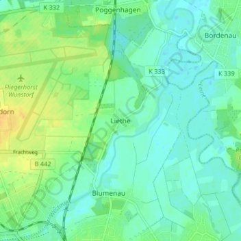
Name: Liethe topographic map, elevation, terrain.

Location: Liethe, Wunstorf, Region Hannover, Lower Saxony, Germany (52.42816 9.43536 52.46816 9.47536)

Average elevation: 151 ft

Minimum elevation: 121 ft

Maximum elevation: 200 ft

Other topographic maps

Click on a map to view its topography, its elevation and its terrain.

Steinhude

Germany > Lower Saxony > Region Hannover > Wunstorf

Average elevation: 141 ft

Gear up for your next adventure:

🧭Orienteering Set - Complete compass and map reading kit
📶Vehicle Signal Boosters - Improve reception in rural areas while driving to trailheads
📦Dry Bags Set - Waterproof storage for electronics and clothes
🚑Emergency Bivvies - Heat-reflective sleeping bags for survival situations
🦟Ultrasonic Repellers - Create a bug-free zone at your camp or rest stop

As an Amazon Associate, this site earns from qualifying purchases at no extra cost to you.