
Make a donation
Gear up for your next adventure:
As an Amazon Associate, this site earns from qualifying purchases at no extra cost to you.
Can Salvà topographic map
Click on the map to display elevation.
Make a donation
Gear up for your next adventure:
As an Amazon Associate, this site earns from qualifying purchases at no extra cost to you.
About this map
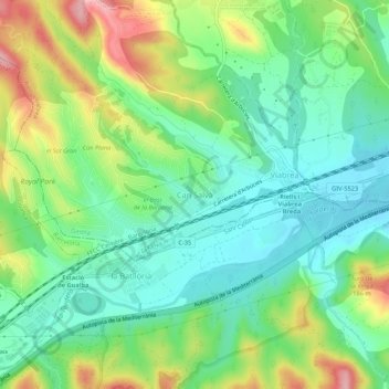
Name: Can Salvà topographic map, elevation, terrain.
Average elevation: 417 ft
Minimum elevation: 243 ft
Maximum elevation: 751 ft
Make a donation
Gear up for your next adventure:
As an Amazon Associate, this site earns from qualifying purchases at no extra cost to you.
Other topographic maps
Click on a map to view its topography, its elevation and its terrain.
Make a donation
Gear up for your next adventure:
As an Amazon Associate, this site earns from qualifying purchases at no extra cost to you.
Sant Hilari Sacalm
Aunque no consigue la mayor altitud, San Hilario Sacalm es el municipio de la Selva más montañoso, rodeado por la llanura llamada el Pla de les Arenes (1086 m) al oeste, la sierra de las Guillerías (1182 m) al noroeste, la montaña de Sant Miquel (1204 m) al noreste, y la sierra del Pedró (929 m) al este.…
Average elevation: 2,326 ft
Make a donation
Gear up for your next adventure:
As an Amazon Associate, this site earns from qualifying purchases at no extra cost to you.
Vidreres
El relieve del municipio es montañoso por el este y llano por el oeste. Las montañas de la zona oriental forman parte de la Cordillera Litoral, desde donde descienden numerosas rieras. La altitud oscila entre los 423 m (Puig Ventós) y los 73 m cerca del límite con Massanet de la Selva. El pueblo se alza a…
Average elevation: 430 ft
Sils
El relieve es predominantemente llano, al ocupar buena parte del terreno desecado que ocupada en antiguo lago de Sils. Esta depresión representa la finalización septentrional de lo que se conoce por depresión prelitoral catalana, conjunto de tierras bajas que separan la cordillera Litoral de la Prelitoral.…
Average elevation: 331 ft
Anglès
La villa gerundense se sitúa en medio de un extenso valle que dista 17 km de Gerona, 12 km de Santa Coloma de Farnés (capital de la comarca), 100 km de la ciudad de Barcelona y 40 km de la Costa Brava. La villa antigua se alza sobre una pequeña elevación situada en medio de una llanura fértil en el lado…
Average elevation: 1,033 ft
Make a donation
Gear up for your next adventure:
As an Amazon Associate, this site earns from qualifying purchases at no extra cost to you.
Riudellots de la Selva
Su geografía es un tanto especial, ya que ocupa una parte de la zona drenada del río Oñar. Este río es el principal protagonista de la población, dado que a su paso deja numerosos afluentes que rodean el pueblo de agua. La altitud oscila entre los 125 y los 92 metros de altitud. El pueblo se alza a 98…
Average elevation: 354 ft
Caldes de Malavella
El relieve del municipio se caracteriza por un extenso valle situado entre las cuencas de los ríos Ter y Tordera, quedando al este la cordillera Litoral. El norte forma parte de la cuenca del río Oñar, donde van a parar varias rieras que pasan por el municipio. El sur y el sureste del territorio es más…
Average elevation: 413 ft
Amer
También cabe destacar la presencia de diferentes estrucrutras dolménicas prácticamente arrasadas. Siguiendo con el listado de yacimientos arqueológicos, en el Cau Negre de Sant Roc, en 1981 se excavó lo que parecían los restos de una incineración del Bronce Final (1200-650 aC). De la época ibérica se…
Average elevation: 1,250 ft
Make a donation
Gear up for your next adventure:
As an Amazon Associate, this site earns from qualifying purchases at no extra cost to you.
Riera de Santa Coloma
España > Cataluña > la Selva > Santa Coloma de Farners
Average elevation: 1,283 ft
Castell de Sant Joan
España > Cataluña > la Selva > Blanes
La torre de San Juan (en catalán, torre de Sant Joan) es una fortificación española situada en la cima del cerro San Juan en Blanes (Gerona). Desde allí, a 180 metros de altitud, se puede contemplar una vista de la ciudad y la comarca de la Selva y, por el sur, en los días despejados, se puede llegar a…
Average elevation: 108 ft
Make a donation
Gear up for your next adventure:
As an Amazon Associate, this site earns from qualifying purchases at no extra cost to you.
Cala Pola
España > Cataluña > la Selva > Tossa de Mar > Pola Giverola Resort
Average elevation: 174 ft
Maçanet de la Selva
El relieve del municipio es predominantemente montañoso, de baja altura por la cercanía de la costa. Por el norte discurren la acequia de Sils y la riera de Pins, haciendo de límite natural con el municipio de Sils. Por el oeste, es la riera de Santa Coloma la que marca el límite con Riudarenas y Massanas.…
Average elevation: 338 ft
Make a donation
Gear up for your next adventure:
As an Amazon Associate, this site earns from qualifying purchases at no extra cost to you.
Make a donation
Gear up for your next adventure:
As an Amazon Associate, this site earns from qualifying purchases at no extra cost to you.
Make a donation
Gear up for your next adventure:
As an Amazon Associate, this site earns from qualifying purchases at no extra cost to you.
Caldes de Malavella
El relieve del municipio se caracteriza por un extenso valle situado entre las cuencas de los ríos Ter y Tordera, quedando al este la cordillera Litoral. El norte forma parte de la cuenca del río Onyar, donde van a parar varias rieras que pasan por el municipio. El sur y el sureste del territorio es más…
Average elevation: 413 ft