
Make a donation
Gear up for your next adventure:
As an Amazon Associate, this site earns from qualifying purchases at no extra cost to you.
Dehrn topographic map
Click on the map to display elevation.
Make a donation
Gear up for your next adventure:
As an Amazon Associate, this site earns from qualifying purchases at no extra cost to you.
About this map
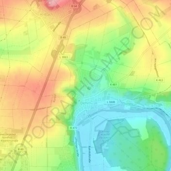
Name: Dehrn topographic map, elevation, terrain.
Location: Dehrn, Runkel, Landkreis Limburg-Weilburg, Hessen, Deutschland (50.40497 8.08354 50.44021 8.12188)
Average elevation: 564 ft
Minimum elevation: 361 ft
Maximum elevation: 794 ft
Make a donation
Gear up for your next adventure:
As an Amazon Associate, this site earns from qualifying purchases at no extra cost to you.
Other topographic maps
Click on a map to view its topography, its elevation and its terrain.
Steeden
Deutschland > Hessen > Landkreis Limburg-Weilburg > Runkel > Steeden
Die in Nord-Süd-Richtung länglich verlaufende, rund 400 Hektar große Gemarkung mit einem Ausläufer nach Osten grenzt im Norden an den Beselicher Ortsteil Niedertiefenbach, im Nordosten an Hofen, im Osten an Schadeck, im Südosten und Süden an die Kernstadt Runkel, im Südwesten an Ennerich und im Westen…
Average elevation: 518 ft