
Make a donation
Gear up for your next adventure:
As an Amazon Associate, this site earns from qualifying purchases at no extra cost to you.
South Governorate topographic map
Click on the map to display elevation.
Make a donation
Gear up for your next adventure:
As an Amazon Associate, this site earns from qualifying purchases at no extra cost to you.
South Governorate
South Governorate (Arabic: الجنوب; transliterated: al-Janub) is one of the governorates of Lebanon. South Lebanon has a population of 500,000 inhabitants and an area of 929.6 km2. The capital is Sidon. The lowest elevation is sea-level; the highest is 1,000 meters. The local population is religiously diverse and includes Shia and Sunni Muslims, Druze, Eastern Orthodox, Maronite, Protestant, and Greek Catholic Christians. Temperatures can drop to 4 °C during winter with much rain and snow on the higher ground. In the humid summer, temperatures can rise to 30 °C in the coastal areas. The governorate has several rivers: the Litani, Deir El Zahrani, Naqoura, Awali, Qasmiye, and Hasbani. The area is famous for its citrus and banana farms. Its main cities are Sidon, Tyre and Jezzine.
Make a donation
Gear up for your next adventure:
As an Amazon Associate, this site earns from qualifying purchases at no extra cost to you.
About this map
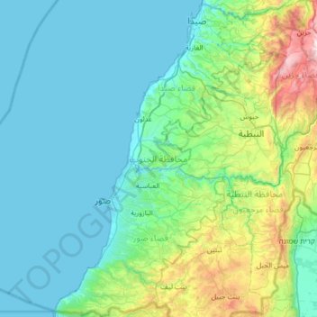
Name: South Governorate topographic map, elevation, terrain.
Location: South Governorate, Lebanon (33.08543 35.10357 33.59503 35.63822)
Average elevation: 823 ft
Minimum elevation: -3 ft
Maximum elevation: 5,092 ft
Make a donation
Gear up for your next adventure:
As an Amazon Associate, this site earns from qualifying purchases at no extra cost to you.
Other topographic maps
Click on a map to view its topography, its elevation and its terrain.
Make a donation
Gear up for your next adventure:
As an Amazon Associate, this site earns from qualifying purchases at no extra cost to you.
Ehden
Ehden is located in the central northern side of Mount Lebanon, with a 1500-metre (at Midan square) elevation from sea level. It is 120 kilometres (75 mi) from Beirut, 30 kilometres (19 mi) from Tripoli and 25 kilometres (16 mi) from Zgharta. Ehden used to be the sole residence for Zghartians prior to the…
Average elevation: 4,429 ft
Make a donation
Gear up for your next adventure:
As an Amazon Associate, this site earns from qualifying purchases at no extra cost to you.
Make a donation
Gear up for your next adventure:
As an Amazon Associate, this site earns from qualifying purchases at no extra cost to you.