
Make a donation
Gear up for your next adventure:
As an Amazon Associate, this site earns from qualifying purchases at no extra cost to you.
North Chili topographic map
Click on the map to display elevation.
Make a donation
Gear up for your next adventure:
As an Amazon Associate, this site earns from qualifying purchases at no extra cost to you.
About this map
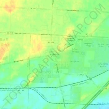
Name: North Chili topographic map, elevation, terrain.
Average elevation: 581 ft
Minimum elevation: 535 ft
Maximum elevation: 630 ft
Monroe County trails, hiking, mountain biking, running and outdoor activities
Make a donation
Gear up for your next adventure:
As an Amazon Associate, this site earns from qualifying purchases at no extra cost to you.
Other topographic maps
Click on a map to view its topography, its elevation and its terrain.
Make a donation
Gear up for your next adventure:
As an Amazon Associate, this site earns from qualifying purchases at no extra cost to you.
Crittenden Road Ball Diamonds
United States > New York > Monroe County > City of Rochester
Average elevation: 528 ft
Make a donation
Gear up for your next adventure:
As an Amazon Associate, this site earns from qualifying purchases at no extra cost to you.
Parma Town Park
United States > New York > Monroe County > Village of Hilton > Parma Center
Average elevation: 341 ft
Black Creek
United States > New York > Monroe County > Town of Brighton > Genesee Junction
Average elevation: 525 ft
Make a donation
Gear up for your next adventure:
As an Amazon Associate, this site earns from qualifying purchases at no extra cost to you.
Town of Mendon
United States > New York > Monroe County
The town is bordered on the north by the town of Pittsford, on the west by the towns of Henrietta and Rush, and on the south and east by Ontario County. Honeoye Creek enters across the southern town line. The town is made up mostly of horse farms and family homes. The highest elevations in Monroe County are in…
Average elevation: 673 ft