
Thank you for supporting this site ❤️
Make a donation
Make a donation
Gear up for your next adventure:
As an Amazon Associate, this site earns from qualifying purchases at no extra cost to you.
Pfeifferberg topographic map
Click on the map to display elevation.
Thank you for supporting this site ❤️
Make a donation
Make a donation
Gear up for your next adventure:
As an Amazon Associate, this site earns from qualifying purchases at no extra cost to you.
About this map
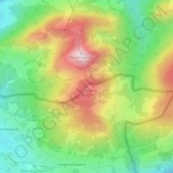
Name: Pfeifferberg topographic map, elevation, terrain.
Location: Pfeifferberg, Jungholz, Bezirk Reutte, Tyrol, 6691, Autriche (47.58520 10.46145 47.58530 10.46155)
Average elevation: 4,026 ft
Minimum elevation: 3,281 ft
Maximum elevation: 5,020 ft
Thank you for supporting this site ❤️
Make a donation
Make a donation
Gear up for your next adventure:
As an Amazon Associate, this site earns from qualifying purchases at no extra cost to you.