Geolocate

Mountain View topographic map

Click on the map to display elevation.

About this map

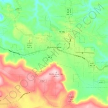
Name: Mountain View topographic map, elevation, terrain.

Location: Mountain View, Stone County, Arkansas, 72560, United States (35.83535 -92.15761 35.89139 -92.06016)

Average elevation: 814 ft

Minimum elevation: 407 ft

Maximum elevation: 1,391 ft

Stone County trails, hiking, mountain biking, running and outdoor activities

Other topographic maps

Click on a map to view its topography, its elevation and its terrain.

Pleasant Grove

United States > Arkansas > Stone County

Average elevation: 548 ft

Fox

United States > Arkansas > Stone County

Average elevation: 1,335 ft

Herd Island

United States > Arkansas > Stone County

Average elevation: 784 ft

Wade Hill

United States > Arkansas > Stone County

Average elevation: 1,053 ft

Herd Island

United States > Arkansas > Stone County

Average elevation: 784 ft

Gear up for your next adventure:

🛏️Cold Weather Sleeping Bag - Warm sleeping bag for cold conditions
😴Insulated Sleeping Pads - Compact and warm pads for high-elevation camping
🪄Magnetic Compass - Accurate compass for navigation
🪶Multi‑Purpose Knife - Useful blade for camp and trail
👖Convertible Hiking Pants - Versatile zip-off pants for changing altitudes and temperatures

As an Amazon Associate, this site earns from qualifying purchases at no extra cost to you.