Geolocate

Fox topographic map

Click on the map to display elevation.

About this map

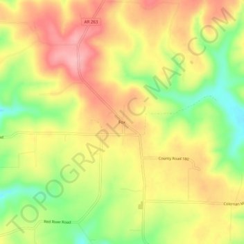
Name: Fox topographic map, elevation, terrain.

Location: Fox, Stone County, Arkansas, 72051, United States (35.77147 -92.31766 35.81147 -92.27766)

Average elevation: 1,335 ft

Minimum elevation: 1,079 ft

Maximum elevation: 1,542 ft

Stone County trails, hiking, mountain biking, running and outdoor activities

Other topographic maps

Click on a map to view its topography, its elevation and its terrain.

Mountain View

United States > Arkansas > Stone County

Average elevation: 814 ft

Mountain View

United States > Arkansas > Stone County

Average elevation: 814 ft

Mountain View

United States > Arkansas > Stone County

Average elevation: 814 ft

Fifty-Six

United States > Arkansas > Stone County

Average elevation: 837 ft

Gear up for your next adventure:

🧺Microfiber Travel Towels - Compact and fast-drying towels for trail use
🎒Outdoor Daypacks - Lightweight backpacks designed for carrying maps and essential gear
Backpacking Tents - Weight-optimized shelters for multi-day topographic surveys
📱Heavy-Duty Phone Cases - Drop-proof and waterproof protection for outdoor navigation
🔊Portable Camp Speaker - Music and alerts at camp

As an Amazon Associate, this site earns from qualifying purchases at no extra cost to you.