
Make a donation
Gear up for your next adventure:
As an Amazon Associate, this site earns from qualifying purchases at no extra cost to you.
Anogia topographic map
Click on the map to display elevation.
Make a donation
Gear up for your next adventure:
As an Amazon Associate, this site earns from qualifying purchases at no extra cost to you.
Anogia
The historian Stelios Spanakis, summarily provides geographical, as well as historical information about Anogia,: “Anogia is a town –municipality in the Mylopotamos Province of the Prefecture of Rethymno. In the 1981 census it numbered 2.449 citizens. It is in the northern reaches of Psiloreitis, at an altitude of 700-790 meters. When in 1182 Crete was divided among the 12 Young Princes of Byzantium, Anogia were given to the family of Fokas. Anogia are referred to by Venetian and Greek scholars and historians as Anogia, or Anoia. In 1593 it was already a significant settlement, numbering 911 citizens. Anogia are referred to as a revolutionary place during the years of Turkish occupation. In 1822, when the Anogians were fighting the Turks in Messara, Serif Pasha found the village empty and put it to the torch. In November 1866, during the Great Cretan Revolt, Resit Pasha tried to capture Anogia, but he was repulsed by the Anogians and other villagers from Mylopotamos.” This tradition continued during the German occupation and in August 1944 the village was once again razed to the ground in reprisal for the local's participation in the resistance.
Make a donation
Gear up for your next adventure:
As an Amazon Associate, this site earns from qualifying purchases at no extra cost to you.
About this map
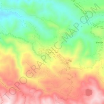
Name: Anogia topographic map, elevation, terrain.
Average elevation: 2,339 ft
Minimum elevation: 1,378 ft
Maximum elevation: 3,379 ft
Make a donation
Gear up for your next adventure:
As an Amazon Associate, this site earns from qualifying purchases at no extra cost to you.
Other topographic maps
Click on a map to view its topography, its elevation and its terrain.
Municipality of Agios Vasileios
Greece > Region of Crete > Rethymno Regional Unit
Average elevation: 810 ft
Myli Gorge
Greece > Region of Crete > Rethymno Regional Unit > Xiro Chorio > Myli
Average elevation: 650 ft
Platis River
Greece > Region of Crete > Rethymno Regional Unit > Agia Galini
Average elevation: 538 ft
Make a donation
Gear up for your next adventure:
As an Amazon Associate, this site earns from qualifying purchases at no extra cost to you.