
Thank you for supporting this site ❤️
Make a donation
Make a donation
Gear up for your next adventure:
As an Amazon Associate, this site earns from qualifying purchases at no extra cost to you.
Perucho topographic map
Click on the map to display elevation.
Thank you for supporting this site ❤️
Make a donation
Make a donation
Gear up for your next adventure:
As an Amazon Associate, this site earns from qualifying purchases at no extra cost to you.
About this map
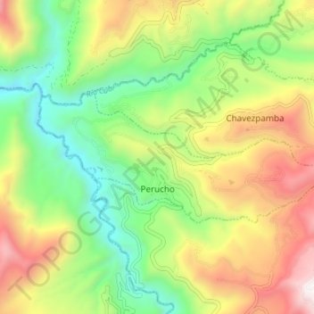
Name: Perucho topographic map, elevation, terrain.
Location: Perucho, Distrito Metropolitano de Quito, Pichincha, Ecuador (0.10172 -78.44982 0.12992 -78.38223)
Average elevation: 6,503 ft
Minimum elevation: 4,734 ft
Maximum elevation: 8,999 ft
Thank you for supporting this site ❤️
Make a donation
Make a donation
Gear up for your next adventure:
As an Amazon Associate, this site earns from qualifying purchases at no extra cost to you.
Other topographic maps
Click on a map to view its topography, its elevation and its terrain.
Parque La Armenia
Ecuador > Pichincha > Distrito Metropolitano de Quito > Conocoto
Average elevation: 8,320 ft