
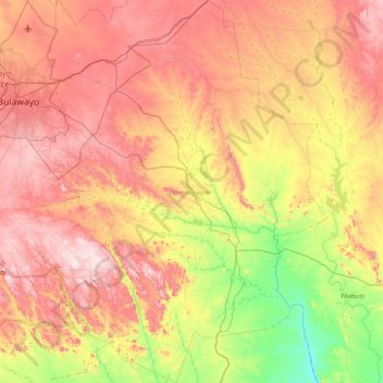
Umzingwane topographic map
Interactive map
Click on the map to display elevation.
About this map
Name: Umzingwane topographic map, elevation, terrain.
Location: Umzingwane, Matabeleland South Province, Zimbabwe (-20.70554 28.66298 -19.95866 29.23222)
Average elevation: 4,039 ft
Minimum elevation: 3,025 ft
Maximum elevation: 5,115 ft
Other topographic maps
Click on a map to view its topography, its elevation and its terrain.
Fort Rixon
Zimbabwe > Matabeleland South Province > Insiza
Fort Rixon, Insiza, Matabeleland South Province, Zimbabwe
Average elevation: 4,239 ft
Gwanda
Zimbabwe > Matabeleland South Province > Gwanda
Gwanda, Matabeleland South Province, Zimbabwe
Average elevation: 3,320 ft