
Make a donation
Gear up for your next adventure:
As an Amazon Associate, this site earns from qualifying purchases at no extra cost to you.
Gwanda topographic map
Click on the map to display elevation.
Make a donation
Gear up for your next adventure:
As an Amazon Associate, this site earns from qualifying purchases at no extra cost to you.
Gwanda
The town is located 134 kilometres (83 mi), by road, south east of the city of Bulawayo, Zimbabwe's second largest city. This location lies on the Bulawayo–Beitbridge Road and the Beitbridge Bulawayo Railway. The town of Beitbridge, at Zimbabwe's border with the Republic of South Africa, lies approximately 197 kilometres (122 mi), further southeast on Highway A-6. The coordinates of Gwanda, Zimbabwe are: 20°56'20.0"S, 29°01'07.0"E (Latitude:-20.938889; Longitude:29.018611). Gwanda sits at an average elevation of 3,300 feet (1,006 m) above mean sea level. Gwanda is known to have long, hot summers, and short, cool winters. Gwanda is also quite dry as compared to the rest of the country, and is therefore prone to drought.
Make a donation
Gear up for your next adventure:
As an Amazon Associate, this site earns from qualifying purchases at no extra cost to you.
About this map
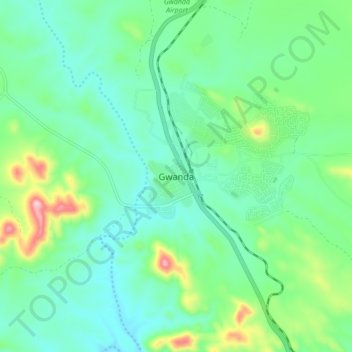
Name: Gwanda topographic map, elevation, terrain.
Location: Gwanda, Matabeleland South Province, Zimbabwe (-20.98143 28.96369 -20.90143 29.04369)
Average elevation: 3,320 ft
Minimum elevation: 3,087 ft
Maximum elevation: 4,029 ft
Make a donation
Gear up for your next adventure:
As an Amazon Associate, this site earns from qualifying purchases at no extra cost to you.
Other topographic maps
Click on a map to view its topography, its elevation and its terrain.