Geolocate

Cub Lake topographic map

Click on the map to display elevation.

About this map

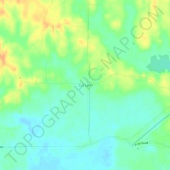
Name: Cub Lake topographic map, elevation, terrain.

Location: Cub Lake, DeSoto County, Mississippi, United States (34.76649 -90.16926 34.80649 -90.12926)

Average elevation: 233 ft

Minimum elevation: 187 ft

Maximum elevation: 302 ft

DeSoto County trails, hiking, mountain biking, running and outdoor activities

Gear up for your next adventure:

📻Weather Alert Radios - Stay informed of storm risks while off-the-grid
🧼Biodegradable Camping Soap - Eco‑friendly soap for outdoor hygiene
🦶Hiking Gaiters - Keep debris and water out of your boots
🛌Ultralight Sleeping Bags - Compact down bags for cold nights in the wilderness
🪶Paracord Bracelet - Survival bracelet with built‑in tools

As an Amazon Associate, this site earns from qualifying purchases at no extra cost to you.