
Bend topographic map
Click on the map to display elevation.
About this map
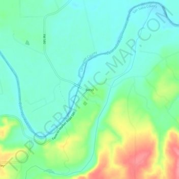
Name: Bend topographic map, elevation, terrain.
Location: Bend, San Saba County, Texas, United States (31.07961 -98.53170 31.11961 -98.49170)
Average elevation: 1,148 ft
Minimum elevation: 1,063 ft
Maximum elevation: 1,342 ft
San Saba County trails, hiking, mountain biking, running and outdoor activities
Other topographic maps
Click on a map to view its topography, its elevation and its terrain.