Geolocate

Kannad topographic map

Click on the map to display elevation.

About this map

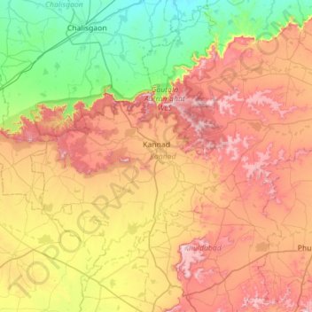
Name: Kannad topographic map, elevation, terrain.

Location: Kannad, Aurangabad, Maharashtra, India (19.99896 74.90543 20.49906 75.46676)

Average elevation: 1,916 ft

Minimum elevation: 997 ft

Maximum elevation: 3,133 ft

Gear up for your next adventure:

🪶LED Camping Lantern - Bright lantern for camp lighting
🥾Women's Hiking Boots - Top-rated trail boots with ankle support and superior grip
🪓Survival Multi‑Tool - Versatile tool for camp and trail tasks
🔊Portable Camp Speaker - Music and alerts at camp
🔌USB Car Charger - Car charger for on‑the‑go power needs

As an Amazon Associate, this site earns from qualifying purchases at no extra cost to you.