
Make a donation
Gear up for your next adventure:
As an Amazon Associate, this site earns from qualifying purchases at no extra cost to you.
Ashby St. Mary topographic map
Click on the map to display elevation.
Make a donation
Gear up for your next adventure:
As an Amazon Associate, this site earns from qualifying purchases at no extra cost to you.
Ashby St. Mary
Ashby's topography is, like most of East Anglia, made up of river meadows and flat agricultural landscape. The geology mostly consists of Cainozoic Sedimentary rock, with a layer of boulder clay and sand laid down in the last ice age. Ashby St Mary has slightly acidic loamy and clayey soils with impeded drainage, and low carbon. The cropping of Ashby is reasonably flexible but more suited to autumn sown crops and grassland.
Make a donation
Gear up for your next adventure:
As an Amazon Associate, this site earns from qualifying purchases at no extra cost to you.
About this map
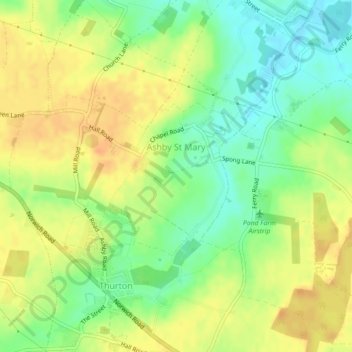
Name: Ashby St. Mary topographic map, elevation, terrain.
Location: Ashby St. Mary, South Norfolk, Norfolk, England, United Kingdom (52.55960 1.42062 52.57195 1.45185)
Average elevation: 66 ft
Minimum elevation: 0 ft
Maximum elevation: 118 ft
Make a donation
Gear up for your next adventure:
As an Amazon Associate, this site earns from qualifying purchases at no extra cost to you.
Other topographic maps
Click on a map to view its topography, its elevation and its terrain.
Poringland Wood
United Kingdom > England > Norfolk > South Norfolk > Framingham Earl
Average elevation: 164 ft
Make a donation
Gear up for your next adventure:
As an Amazon Associate, this site earns from qualifying purchases at no extra cost to you.
Fundenhall
United Kingdom > England > Norfolk > South Norfolk > Ashwellthorpe and Fundenhall
Average elevation: 164 ft
Make a donation
Gear up for your next adventure:
As an Amazon Associate, this site earns from qualifying purchases at no extra cost to you.
Make a donation
Gear up for your next adventure:
As an Amazon Associate, this site earns from qualifying purchases at no extra cost to you.
Highoak
United Kingdom > England > Norfolk > South Norfolk > Morley St Botolph
Average elevation: 154 ft
Make a donation
Gear up for your next adventure:
As an Amazon Associate, this site earns from qualifying purchases at no extra cost to you.
Beckhithe
United Kingdom > England > Norfolk > South Norfolk > Little Melton > Beckhithe
Average elevation: 121 ft
Make a donation
Gear up for your next adventure:
As an Amazon Associate, this site earns from qualifying purchases at no extra cost to you.
Make a donation
Gear up for your next adventure:
As an Amazon Associate, this site earns from qualifying purchases at no extra cost to you.
Make a donation
Gear up for your next adventure:
As an Amazon Associate, this site earns from qualifying purchases at no extra cost to you.