
Thank you for supporting this site ❤️
Make a donation
Make a donation
Gear up for your next adventure:
As an Amazon Associate, this site earns from qualifying purchases at no extra cost to you.
Fontia topographic map
Click on the map to display elevation.
Thank you for supporting this site ❤️
Make a donation
Make a donation
Gear up for your next adventure:
As an Amazon Associate, this site earns from qualifying purchases at no extra cost to you.
About this map
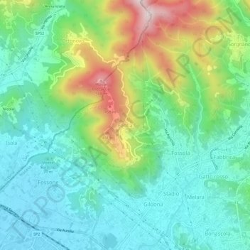
Name: Fontia topographic map, elevation, terrain.
Location: Fontia, Carrara, Massa-Carrara, Tuscany, 54033, Italy (44.05561 10.04567 44.09561 10.08567)
Average elevation: 535 ft
Minimum elevation: 0 ft
Maximum elevation: 1,834 ft
Thank you for supporting this site ❤️
Make a donation
Make a donation
Gear up for your next adventure:
As an Amazon Associate, this site earns from qualifying purchases at no extra cost to you.