
Make a donation
Gear up for your next adventure:
As an Amazon Associate, this site earns from qualifying purchases at no extra cost to you.
Cintruénigo topographic map
Click on the map to display elevation.
Make a donation
Gear up for your next adventure:
As an Amazon Associate, this site earns from qualifying purchases at no extra cost to you.
Cintruénigo
La localidad de Cintruénigo está situada al sur de la Comunidad Foral de Navarra dentro de la Ribera de Navarra y a una altitud de 391 msnm. Su término municipal tiene una superficie de 35,4 km² y limita al norte y Noroeste con el municipio de Corella, al Este y Sur con el de Tudela y al oeste con el de Fitero.
Make a donation
Gear up for your next adventure:
As an Amazon Associate, this site earns from qualifying purchases at no extra cost to you.
About this map
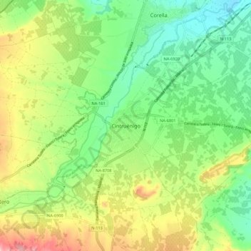
Name: Cintruénigo topographic map, elevation, terrain.
Location: Cintruénigo, Navarra, 31592, España (42.03991 -1.84350 42.11991 -1.76350)
Average elevation: 1,342 ft
Minimum elevation: 1,102 ft
Maximum elevation: 1,739 ft
Make a donation
Gear up for your next adventure:
As an Amazon Associate, this site earns from qualifying purchases at no extra cost to you.