
Thank you for supporting this site ❤️
Make a donation
Make a donation
Gear up for your next adventure:
As an Amazon Associate, this site earns from qualifying purchases at no extra cost to you.
Beas River topographic map
Click on the map to display elevation.
Thank you for supporting this site ❤️
Make a donation
Make a donation
Gear up for your next adventure:
As an Amazon Associate, this site earns from qualifying purchases at no extra cost to you.
About this map
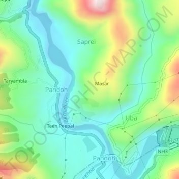
Name: Beas River topographic map, elevation, terrain.
Location: Beas River, Pandoh, Mandi, Himachal Pradesh, 175124, India (31.66544 77.04320 31.69261 77.06479)
Average elevation: 3,156 ft
Minimum elevation: 2,690 ft
Maximum elevation: 4,298 ft
Thank you for supporting this site ❤️
Make a donation
Make a donation
Gear up for your next adventure:
As an Amazon Associate, this site earns from qualifying purchases at no extra cost to you.