
Make a donation
Gear up for your next adventure:
As an Amazon Associate, this site earns from qualifying purchases at no extra cost to you.
Mount Ivy topographic map
Click on the map to display elevation.
Make a donation
Gear up for your next adventure:
As an Amazon Associate, this site earns from qualifying purchases at no extra cost to you.
Mount Ivy
The name Mount Ivy is said to have been given to the locality because of its elevation and ivy swamp.
Make a donation
Gear up for your next adventure:
As an Amazon Associate, this site earns from qualifying purchases at no extra cost to you.
About this map
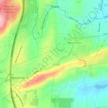
Name: Mount Ivy topographic map, elevation, terrain.
Average elevation: 404 ft
Minimum elevation: 125 ft
Maximum elevation: 896 ft
Rockland County trails, hiking, mountain biking, running and outdoor activities
Make a donation
Gear up for your next adventure:
As an Amazon Associate, this site earns from qualifying purchases at no extra cost to you.
Other topographic maps
Click on a map to view its topography, its elevation and its terrain.
Evans Park Trail/Woods
United States > New York > Rockland County > Pearl River
Average elevation: 269 ft
Palisades
United States > New York > Rockland County > Palisades > Palisades
Average elevation: 118 ft
Make a donation
Gear up for your next adventure:
As an Amazon Associate, this site earns from qualifying purchases at no extra cost to you.
Tomkins Cove
United States > New York > Rockland County > Town of Stony Point
Average elevation: 223 ft
Make a donation
Gear up for your next adventure:
As an Amazon Associate, this site earns from qualifying purchases at no extra cost to you.
Kings Gate Park
United States > New York > Rockland County > Village of Montebello
Average elevation: 505 ft