
Thank you for supporting this site ❤️
Make a donation
Make a donation
Gear up for your next adventure:
As an Amazon Associate, this site earns from qualifying purchases at no extra cost to you.
Akıncı topographic map
Click on the map to display elevation.
Thank you for supporting this site ❤️
Make a donation
Make a donation
Gear up for your next adventure:
As an Amazon Associate, this site earns from qualifying purchases at no extra cost to you.
About this map
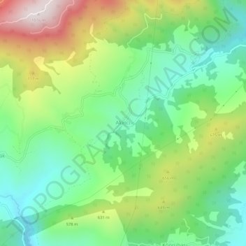
Name: Akıncı topographic map, elevation, terrain.
Location: Akıncı, Geyve, Sakarya, Marmara Region, Turkey (40.55544 30.25436 40.59544 30.29436)
Average elevation: 1,690 ft
Minimum elevation: 663 ft
Maximum elevation: 3,510 ft
Thank you for supporting this site ❤️
Make a donation
Make a donation
Gear up for your next adventure:
As an Amazon Associate, this site earns from qualifying purchases at no extra cost to you.