
Make a donation
Gear up for your next adventure:
As an Amazon Associate, this site earns from qualifying purchases at no extra cost to you.
Gürzenich topographic map
Click on the map to display elevation.
Make a donation
Gear up for your next adventure:
As an Amazon Associate, this site earns from qualifying purchases at no extra cost to you.
Gürzenich
Vom 6. Oktober 1908 an wurde Gürzenich von der Straßenbahnlinie 3 der Dürener Kreisbahn (DKB) bedient. Die Strecke führte durch die heutige Valencienner Straße und die heutige Schillingsstraße und endete in Höhe der Kirche mit einem Umsetzgleis.
Make a donation
Gear up for your next adventure:
As an Amazon Associate, this site earns from qualifying purchases at no extra cost to you.
About this map
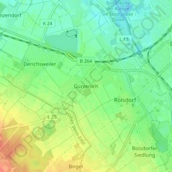
Name: Gürzenich topographic map, elevation, terrain.
Average elevation: 440 ft
Minimum elevation: 387 ft
Maximum elevation: 522 ft
Make a donation
Gear up for your next adventure:
As an Amazon Associate, this site earns from qualifying purchases at no extra cost to you.