
Make a donation
Gear up for your next adventure:
As an Amazon Associate, this site earns from qualifying purchases at no extra cost to you.
Parc Jacques-Cartier topographic map
Click on the map to display elevation.
Make a donation
Gear up for your next adventure:
As an Amazon Associate, this site earns from qualifying purchases at no extra cost to you.
About this map
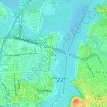
Name: Parc Jacques-Cartier topographic map, elevation, terrain.
Average elevation: 171 ft
Minimum elevation: 128 ft
Maximum elevation: 322 ft
Make a donation
Gear up for your next adventure:
As an Amazon Associate, this site earns from qualifying purchases at no extra cost to you.
Other topographic maps
Click on a map to view its topography, its elevation and its terrain.
Rivière des Outaouais
Canada > Québec > Gatineau > Pontiac
Il y a 9 000 ans, la mer de Champlain (carte), créée à la suite du retrait des glaciers, commence à se retirer vers l'est, formant ainsi les vallées de l'Outaouais et du St-Laurent. À son plus haut niveau, elle occupait les terres situées sous 200 m d'altitude (par rapport au niveau actuel des mers).
Average elevation: 1,043 ft
Make a donation
Gear up for your next adventure:
As an Amazon Associate, this site earns from qualifying purchases at no extra cost to you.