Geolocate

Tua topographic map

Click on the map to display elevation.

About this map

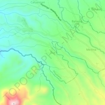
Name: Tua topographic map, elevation, terrain.

Location: Tua, Magallanes, Cavite, Calabarzon, 4113, Philippines (14.11443 120.76058 14.15443 120.80058)

Average elevation: 883 ft

Minimum elevation: 436 ft

Maximum elevation: 1,837 ft

Gear up for your next adventure:

📌Outdoor GPS Map App - Apps and devices for digital topographic navigation
Solar GPS Watches - Advanced multisport watches with built-in topographic maps
🛠️Backpacking Tool Kit - Essential toolkit for outdoor repairs
🔥Camping Stove - Portable stove for camping and backcountry cooking
🔦Compact Flashlight - Reliable flashlight for emergencies

As an Amazon Associate, this site earns from qualifying purchases at no extra cost to you.