
Make a donation
Gear up for your next adventure:
As an Amazon Associate, this site earns from qualifying purchases at no extra cost to you.
Mont Sainte-Anne topographic map
Click on the map to display elevation.
Make a donation
Gear up for your next adventure:
As an Amazon Associate, this site earns from qualifying purchases at no extra cost to you.
Mont Sainte-Anne
Le mont Sainte-Anne est une montagne canadienne faisant partie des monts Chic-Chocs dans les Appalaches située à Percé sur la péninsule gaspésienne dans la région de la Gaspésie–Îles-de-la-Madeleine au Québec. Son altitude est estimée à 340 mètres.
Make a donation
Gear up for your next adventure:
As an Amazon Associate, this site earns from qualifying purchases at no extra cost to you.
About this map
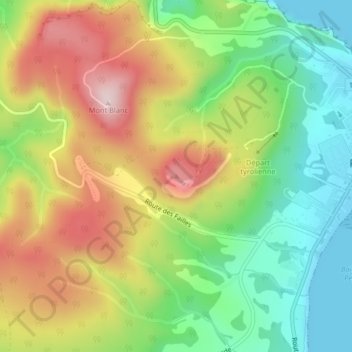
Name: Mont Sainte-Anne topographic map, elevation, terrain.
Average elevation: 531 ft
Minimum elevation: -3 ft
Maximum elevation: 1,207 ft
Make a donation
Gear up for your next adventure:
As an Amazon Associate, this site earns from qualifying purchases at no extra cost to you.
Other topographic maps
Click on a map to view its topography, its elevation and its terrain.