
Make a donation
Gear up for your next adventure:
As an Amazon Associate, this site earns from qualifying purchases at no extra cost to you.
Wolfersheim topographic map
Click on the map to display elevation.
Make a donation
Gear up for your next adventure:
As an Amazon Associate, this site earns from qualifying purchases at no extra cost to you.
Wolfersheim
Wolfersheim liegt im Südosten des Saarlandes inmitten des UNESCO Biosphärenreservates Bliesgau, rund 6 km südwestlich von Blieskastel am östlichen Hang des Kalbenberges (384,8 m ü. NHN) auf einer Höhe von 276 m ü. NHN.
Make a donation
Gear up for your next adventure:
As an Amazon Associate, this site earns from qualifying purchases at no extra cost to you.
About this map
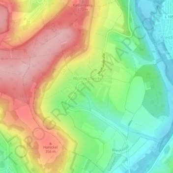
Name: Wolfersheim topographic map, elevation, terrain.
Location: Wolfersheim, Blieskastel, Saarpfalz-Kreis, Saarland, Deutschland (49.17650 7.21093 49.20316 7.24900)
Average elevation: 955 ft
Minimum elevation: 676 ft
Maximum elevation: 1,280 ft
Make a donation
Gear up for your next adventure:
As an Amazon Associate, this site earns from qualifying purchases at no extra cost to you.
Other topographic maps
Click on a map to view its topography, its elevation and its terrain.
Bierbach
Deutschland > Saarland > Saarpfalz-Kreis > Blieskastel
Der Gollenstein wurde vor 4000 Jahren errichtet. Er gilt als der größte Menhir Mitteleuropas und als eines der ältesten Kulturdenkmäler in Deutschland. Zwölf Grabhügel an der Straße von Böckweiler nach Mimbach stammen aus der Hallstattzeit. Auf dem Höhenrücken zwischen Wolfersheim und Rubenheim…
Average elevation: 902 ft