Geolocate

High Ridge Township topographic map

Click on the map to display elevation.

High Ridge Township

The township was so named on account of its lofty elevation.

Wikipedia (CC-BY-SA 3.0)

About this map

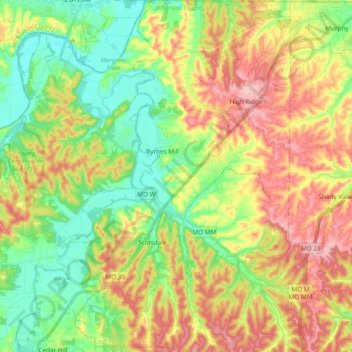
Name: High Ridge Township topographic map, elevation, terrain.

Location: High Ridge Township, Jefferson County, Missouri, 63049, United States (38.35229 -90.63189 38.50175 -90.51234)

Average elevation: 643 ft

Minimum elevation: 404 ft

Maximum elevation: 958 ft

Jefferson County trails, hiking, mountain biking, running and outdoor activities

Other topographic maps

Click on a map to view its topography, its elevation and its terrain.

Local

United States > Missouri > Jefferson County

Average elevation: 577 ft

High Ridge

United States > Missouri > Jefferson County

Average elevation: 807 ft

House Springs

United States > Missouri > Jefferson County

Average elevation: 577 ft

Dittmer

United States > Missouri > Jefferson County

Average elevation: 633 ft

House Springs

United States > Missouri > Jefferson County

Average elevation: 577 ft

Gear up for your next adventure:

🧭Orienteering Set - Complete compass and map reading kit
🧭Hiking Compass - Precision compass for reliable navigation in the wilderness
🥤Water Filter Bottle - All‑in‑one filter bottle for safe hydration
🛠️Backpacking Tool Kit - Essential toolkit for outdoor repairs
🧦Hiking Socks - Comfortable socks to prevent blisters on long hikes

As an Amazon Associate, this site earns from qualifying purchases at no extra cost to you.