
Lacey topographic map
Click on the map to display elevation.
About this map
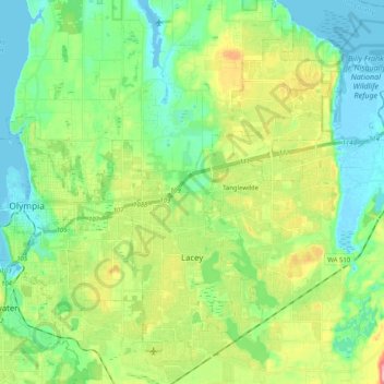
Name: Lacey topographic map, elevation, terrain.
Location: Lacey, Thurston County, Washington, United States (46.97935 -122.83936 47.11934 -122.73824)
Average elevation: 154 ft
Minimum elevation: -10 ft
Maximum elevation: 509 ft
Thurston County trails, hiking, mountain biking, running and outdoor activities
Other topographic maps
Click on a map to view its topography, its elevation and its terrain.
Centralia Coal Mine Dam No 32B
United States > Washington > Thurston County > Tono
Average elevation: 341 ft