
Make a donation
Gear up for your next adventure:
As an Amazon Associate, this site earns from qualifying purchases at no extra cost to you.
Le Mazelet topographic map
Click on the map to display elevation.
Make a donation
Gear up for your next adventure:
As an Amazon Associate, this site earns from qualifying purchases at no extra cost to you.
About this map
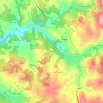
Name: Le Mazelet topographic map, elevation, terrain.
Average elevation: 3,734 ft
Minimum elevation: 3,465 ft
Maximum elevation: 3,996 ft
Make a donation
Gear up for your next adventure:
As an Amazon Associate, this site earns from qualifying purchases at no extra cost to you.
Other topographic maps
Click on a map to view its topography, its elevation and its terrain.
Rieutort-de-Randon
France > Occitanie > Lozère > Monts-de-Randon
Le village est érigé à 1 150 mètres d'altitude et se situe par la route à 18 kilomètres de Mende, préfecture de la Lozère. Bien qu'il ne se situe pas en haute montagne, le village est érigé en moyenne altitude et subit ainsi un climat typiquement montagnard du Massif Central, c'est-à-dire assez…
Average elevation: 4,006 ft