Geolocate

Sebastopol topographic map

Click on the map to display elevation.

About this map

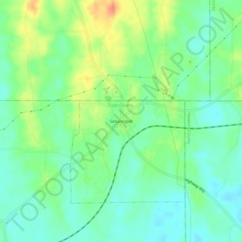
Name: Sebastopol topographic map, elevation, terrain.

Location: Sebastopol, Scott County, Mississippi, 39359, United States (32.55292 -89.35506 32.59292 -89.31506)

Average elevation: 413 ft

Minimum elevation: 358 ft

Maximum elevation: 512 ft

Scott County trails, hiking, mountain biking, running and outdoor activities

Gear up for your next adventure:

🗺️Topographic Maps - Detailed topo maps for hiking, exploring and outdoor navigation
🪓Survival Multi‑Tool - Versatile tool for camp and trail tasks
🦺Reflective Outdoor Gear - Safety gear for low‑light conditions
🧣Merino Neck Gaiters - Multi-functional headwear for wind and sun protection
🧷Carabiner Set - Durable clips for gear attachment

As an Amazon Associate, this site earns from qualifying purchases at no extra cost to you.