
Make a donation
Gear up for your next adventure:
As an Amazon Associate, this site earns from qualifying purchases at no extra cost to you.
Chalk Bluff topographic map
Click on the map to display elevation.
Make a donation
Gear up for your next adventure:
As an Amazon Associate, this site earns from qualifying purchases at no extra cost to you.
About this map
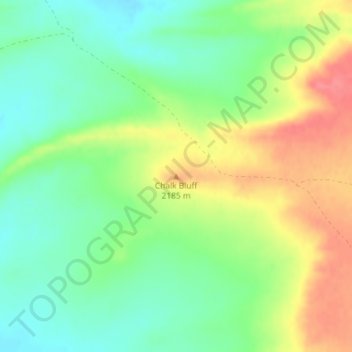
Name: Chalk Bluff topographic map, elevation, terrain.
Location: Chalk Bluff, Albany County, Wyoming, United States (41.80714 -105.75144 41.80724 -105.75134)
Average elevation: 7,064 ft
Minimum elevation: 6,969 ft
Maximum elevation: 7,198 ft
Make a donation
Gear up for your next adventure:
As an Amazon Associate, this site earns from qualifying purchases at no extra cost to you.
Other topographic maps
Click on a map to view its topography, its elevation and its terrain.
Laramie
United States > Wyoming > Albany County
Laramie is on a high plain between two mountain ranges, the Snowy Range, about 30 miles (48 km) to the west, and the Laramie Range, 7 miles (11 km) to the east. The city's elevation above sea level is approximately 7,165 feet (2,184 m). The Laramie River runs through Laramie toward its confluence with the…
Average elevation: 7,280 ft
Make a donation
Gear up for your next adventure:
As an Amazon Associate, this site earns from qualifying purchases at no extra cost to you.
Laramie
United States > Wyoming > Albany County
Laramie (/ˈlærəmi/) is a city in and the county seat of Albany County, Wyoming, United States, known for its high elevation at 7,200 feet (2,200 m), railroad history, and is the home of the University of Wyoming. The population was 31,407 at the 2020 census, making it the fourth-most populous city in…
Average elevation: 7,277 ft
Laramie
United States > Wyoming > Albany County
Laramie (/ˈlærəmi/) is a city in and the county seat of Albany County, Wyoming, United States, known for its high elevation at 7,200 feet (2,200 m), for its railroad history, and as the home of the University of Wyoming. The population was 31,407 at the 2020 census, making it the fourth-most populous city…
Average elevation: 7,277 ft
Laramie
United States > Wyoming > Albany County
Laramie (/ˈlærəmi/) is a city in and the county seat of Albany County, Wyoming, United States, known for its high elevation at 7,200 feet (2,200 m), railroad history, and as the higher-education center for the state of Wyoming. The population was estimated 31,407 in 2020, making it the 4th most populous…
Average elevation: 7,280 ft