
Make a donation
Gear up for your next adventure:
As an Amazon Associate, this site earns from qualifying purchases at no extra cost to you.
Chaumie topographic map
Click on the map to display elevation.
Make a donation
Gear up for your next adventure:
As an Amazon Associate, this site earns from qualifying purchases at no extra cost to you.
About this map
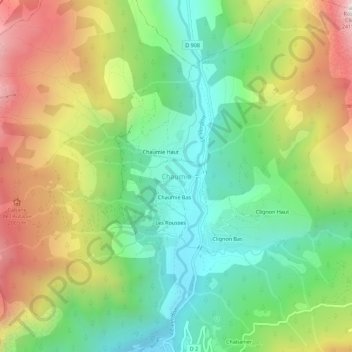
Name: Chaumie topographic map, elevation, terrain.
Average elevation: 5,554 ft
Minimum elevation: 4,088 ft
Maximum elevation: 7,789 ft
Make a donation
Gear up for your next adventure:
As an Amazon Associate, this site earns from qualifying purchases at no extra cost to you.
Other topographic maps
Click on a map to view its topography, its elevation and its terrain.
Lac de Sainte-Croix
France > Provence-Alpes-Côte d'Azur > Alpes-de-Haute-Provence > Sainte-Croix-du-Verdon
Average elevation: 1,916 ft
Val-de-Chalvagne
France > Provence-Alpes-Côte d'Azur > Alpes-de-Haute-Provence
Average elevation: 3,140 ft
Make a donation
Gear up for your next adventure:
As an Amazon Associate, this site earns from qualifying purchases at no extra cost to you.
Castellane
France > Provence-Alpes-Côte d'Azur > Alpes-de-Haute-Provence
Catellane's largest fountain, in the main square, features a pyramid on which is carved a compass crossed by a carpenter's square, two chisels and a mallet, emblems of the Freemasons. At the top of the pyramid is a pedestal with a ball. On National Street, two doors have transoms or capitals with volutes, and…
Average elevation: 3,583 ft
La Bréole
France > Provence-Alpes-Côte d'Azur > Alpes-de-Haute-Provence > Ubaye-Serre-Ponçon
Average elevation: 3,428 ft
Annot
France > Provence-Alpes-Côte d'Azur > Alpes-de-Haute-Provence
The village is located within a resurgence of sandstone amidst limestone mountains at 680 m altitude. This resurgence is up to 250m thick. The rocky ridge overlooking the village is formed of sandstone. The debris that has formed below in picturesque shapes with names such as: the Dent du Diable (Tooth of the…
Average elevation: 3,488 ft
Make a donation
Gear up for your next adventure:
As an Amazon Associate, this site earns from qualifying purchases at no extra cost to you.
Dauphin
France > Provence-Alpes-Côte d'Azur > Alpes-de-Haute-Provence > Dauphin
Average elevation: 1,503 ft
Saint-Paul-sur-Ubaye
France > Provence-Alpes-Côte d'Azur > Alpes-de-Haute-Provence
Average elevation: 7,316 ft
Make a donation
Gear up for your next adventure:
As an Amazon Associate, this site earns from qualifying purchases at no extra cost to you.