
Yale topographic map
Interactive map
Click on the map to display elevation.
About this map
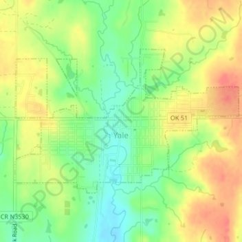
Name: Yale topographic map, elevation, terrain.
Location: Yale, Payne County, Oklahoma, United States (36.10778 -96.71386 36.12386 -96.68287)
Average elevation: 869 ft
Minimum elevation: 781 ft
Maximum elevation: 955 ft
Other topographic maps
Click on a map to view its topography, its elevation and its terrain.
Stillwater
United States > Oklahoma > Payne County
Stillwater, Payne County, Oklahoma, United States
Average elevation: 938 ft
The Botanic Garden at Oklahoma State University
United States > Oklahoma > Payne County > Stillwater
The Botanic Garden at Oklahoma State University, Stillwater, Payne County, Oklahoma, 74074, United States
Average elevation: 902 ft
Cushing
United States > Oklahoma > Payne County > Cushing
Cushing, Payne County, Oklahoma, 74023, United States
Average elevation: 906 ft
Stillwater
United States > Oklahoma > Payne County > Stillwater
Stillwater, Payne County, Oklahoma, 74077, United States
Average elevation: 968 ft