Geolocate

Cabintan topographic map

Interactive map

Click on the map to display elevation.

About this map

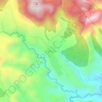
Name: Cabintan topographic map, elevation, terrain.

Location: Cabintan, Ormoc, 4th District, Leyte, Eastern Visayas, 6541, Philippines (11.06068 124.70297 11.10068 124.74297)

Average elevation: 2,260 ft

Minimum elevation: 1,181 ft

Maximum elevation: 3,730 ft

Other topographic maps

Click on a map to view its topography, its elevation and its terrain.

Ormoc

Philippines > Leyte > Ormoc

Ormoc, Leyte 4th District, Leyte, Eastern Visayas, 6541, Philippines

Average elevation: 669 ft

Salvacion

Philippines > Leyte > Ormoc

Salvacion, Ormoc, 4th District, Leyte, Eastern Visayas, 6541, Philippines

Average elevation: 135 ft

Mahayahay

Philippines > Leyte > Ormoc

Mahayahay, Ormoc, 4th District, Leyte, Eastern Visayas, Philippines

Average elevation: 554 ft

Danao

Philippines > Leyte > Ormoc

Danao, Ormoc, Leyte 4th District, Leyte, Eastern Visayas, 6541, Philippines

Average elevation: 2,310 ft

Tambulilid

Philippines > Leyte > Ormoc

Tambulilid, Ormoc, Leyte 4th District, Leyte, Eastern Visayas, 6541, Philippines

Average elevation: 26 ft

Lake Danao

Philippines > Leyte > Ormoc > Danao

Lake Danao, Danao, Ormoc, 4th District, Leyte, Eastern Visayas, 6541, Philippines

Average elevation: 2,392 ft

Binahaan River

Philippines > Leyte > Ormoc

Binahaan River, Ormoc, Leyte 4th District, Leyte, Eastern Visayas, 6541, Philippines

Average elevation: 2,234 ft

Maagonoc

Philippines > Leyte > Ormoc

Maagonoc, Ormoc, Leyte 4th District, Leyte, Eastern Visayas, 6541, Philippines

Average elevation: 1,424 ft

Mount Janagdan

Philippines > Leyte > Ormoc

Mount Janagdan, Ormoc, Leyte 4th District, Leyte, Eastern Visayas, 6541, Philippines

Average elevation: 2,844 ft