Geolocate

Scarbro topographic map

Click on the map to display elevation.

About this map

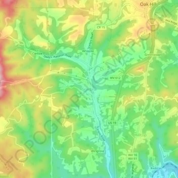
Name: Scarbro topographic map, elevation, terrain.

Location: Scarbro, Fayette County, West Virginia, 25917, United States (37.93317 -81.18566 37.97317 -81.14566)

Average elevation: 1,860 ft

Minimum elevation: 1,565 ft

Maximum elevation: 2,260 ft

Fayette County trails, hiking, mountain biking, running and outdoor activities

Other topographic maps

Click on a map to view its topography, its elevation and its terrain.

Ansted

United States > West Virginia > Fayette County

Average elevation: 1,572 ft

Powellton

United States > West Virginia > Fayette County

Average elevation: 1,552 ft

Smithers

United States > West Virginia > Fayette County

Average elevation: 1,119 ft

Montgomery

United States > West Virginia > Fayette County

Average elevation: 1,106 ft

Pax

United States > West Virginia > Fayette County

Average elevation: 1,821 ft

Gear up for your next adventure:

🌡️Handheld Weather Meters - Measure wind, temp, and pressure for safe mountain travel
🔊Portable Camp Speaker - Music and alerts at camp
🌡️Portable Weather Meter - Track weather conditions on the trail
💧Water Filtration Bottles - Safely drink from streams and lakes while exploring
🪑Portable Camp Table - Compact table for campsite meals

As an Amazon Associate, this site earns from qualifying purchases at no extra cost to you.