
Make a donation
Gear up for your next adventure:
As an Amazon Associate, this site earns from qualifying purchases at no extra cost to you.
Montgomery topographic map
Click on the map to display elevation.
Make a donation
Gear up for your next adventure:
As an Amazon Associate, this site earns from qualifying purchases at no extra cost to you.
About this map
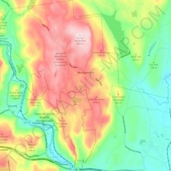
Name: Montgomery topographic map, elevation, terrain.
Location: Montgomery, Hampden County, Massachusetts, United States (42.15585 -72.86847 42.24500 -72.78104)
Average elevation: 663 ft
Minimum elevation: 157 ft
Maximum elevation: 1,322 ft
Hampden County trails, hiking, mountain biking, running and outdoor activities
Make a donation
Gear up for your next adventure:
As an Amazon Associate, this site earns from qualifying purchases at no extra cost to you.
Other topographic maps
Click on a map to view its topography, its elevation and its terrain.
Mittineague
United States > Massachusetts > Hampden County > West Springfield
Average elevation: 161 ft
Make a donation
Gear up for your next adventure:
As an Amazon Associate, this site earns from qualifying purchases at no extra cost to you.
Make a donation
Gear up for your next adventure:
As an Amazon Associate, this site earns from qualifying purchases at no extra cost to you.
Make a donation
Gear up for your next adventure:
As an Amazon Associate, this site earns from qualifying purchases at no extra cost to you.
Palmer Green Estates
United States > Massachusetts > Hampden County > Palmer
Average elevation: 459 ft
Victory Lake Dam
United States > Massachusetts > Hampden County > Camp Spruce Hill
Average elevation: 1,040 ft
Make a donation
Gear up for your next adventure:
As an Amazon Associate, this site earns from qualifying purchases at no extra cost to you.
Make a donation
Gear up for your next adventure:
As an Amazon Associate, this site earns from qualifying purchases at no extra cost to you.
Skyland
United States > Massachusetts > Hampden County > Tolland > Skyland
Average elevation: 1,211 ft
Make a donation
Gear up for your next adventure:
As an Amazon Associate, this site earns from qualifying purchases at no extra cost to you.