Geolocate

Bandy topographic map

Click on the map to display elevation.

About this map

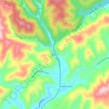
Name: Bandy topographic map, elevation, terrain.

Location: Bandy, Tazewell County, Virginia, United States (37.12289 -81.72095 37.16289 -81.68095)

Average elevation: 2,408 ft

Minimum elevation: 2,051 ft

Maximum elevation: 2,867 ft

Tazewell County trails, hiking, mountain biking, running and outdoor activities

Other topographic maps

Click on a map to view its topography, its elevation and its terrain.

Abbs Valley

United States > Virginia > Tazewell County > Abbs Valley

Average elevation: 2,818 ft

Gratton

United States > Virginia > Tazewell County > Gratton

Average elevation: 3,146 ft

Cedar Bluff

United States > Virginia > Tazewell County

Average elevation: 2,208 ft

Abbs Valley

United States > Virginia > Tazewell County > Abbs Valley

Average elevation: 2,818 ft

Bluefield

United States > Virginia > Tazewell County

Average elevation: 2,785 ft

Cedar Bluff

United States > Virginia > Tazewell County

Average elevation: 2,208 ft

Gear up for your next adventure:

Solar GPS Watches - Advanced multisport watches with built-in topographic maps
Backpacking Tents - Weight-optimized shelters for multi-day topographic surveys
❄️Traction Cleats - Prevent slips on icy trails during winter hikes
🎒Outdoor Daypacks - Lightweight backpacks designed for carrying maps and essential gear
🌡️Handheld Weather Meters - Measure wind, temp, and pressure for safe mountain travel

As an Amazon Associate, this site earns from qualifying purchases at no extra cost to you.