Geolocate

New Boston topographic map

Click on the map to display elevation.

About this map

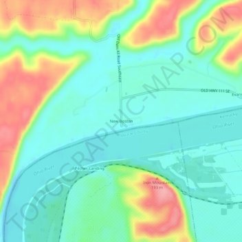
Name: New Boston topographic map, elevation, terrain.

Location: New Boston, Harrison County, Indiana, United States (37.97980 -86.03080 38.01980 -85.99080)

Average elevation: 505 ft

Minimum elevation: 387 ft

Maximum elevation: 755 ft

Harrison County trails, hiking, mountain biking, running and outdoor activities

Other topographic maps

Click on a map to view its topography, its elevation and its terrain.

Lanesville

United States > Indiana > Harrison County

Average elevation: 784 ft

New Amsterdam

United States > Indiana > Harrison County

Average elevation: 495 ft

New Middletown

United States > Indiana > Harrison County

Average elevation: 705 ft

Crandall

United States > Indiana > Harrison County

Average elevation: 712 ft

Laconia

United States > Indiana > Harrison County

Average elevation: 659 ft

Gear up for your next adventure:

🚑Emergency Bivvies - Heat-reflective sleeping bags for survival situations
🧢Outdoor Hiking Hat - Sun protection hat for outdoor explorers
🧦Hiking Socks - Comfortable socks to prevent blisters on long hikes
🛡️Insect Repellent - Protection against bugs during outdoor activities
🚗GPS Dash Cams - Record your scenic drives through mountain passes and canyons

As an Amazon Associate, this site earns from qualifying purchases at no extra cost to you.