Geolocate

Wing topographic map

Click on the map to display elevation.

About this map

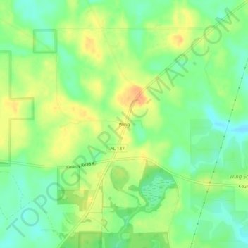
Name: Wing topographic map, elevation, terrain.

Location: Wing, Covington County, Alabama, United States (31.00768 -86.63051 31.04768 -86.59051)

Average elevation: 240 ft

Minimum elevation: 180 ft

Maximum elevation: 302 ft

Covington County trails, hiking, mountain biking, running and outdoor activities

Other topographic maps

Click on a map to view its topography, its elevation and its terrain.

Red Level

United States > Alabama > Covington County

Average elevation: 318 ft

Opp

United States > Alabama > Covington County

Average elevation: 292 ft

Florala

United States > Alabama > Covington County

Average elevation: 279 ft

Conecuh National Forest

United States > Alabama > Covington County

The Conecuh National Forest in southern Alabama covers 83,000 acres (340 km2), along the Alabama - Florida line in Covington and Escambia counties. Topography is level to moderately sloping, broad ridges with stream terraces and broad floodplains.

Average elevation: 246 ft

Heath

United States > Alabama > Covington County

Average elevation: 318 ft

Andalusia

United States > Alabama > Covington County

Average elevation: 282 ft

Florala

United States > Alabama > Covington County

Average elevation: 279 ft

Gear up for your next adventure:

🧯Portable Fire Pit - Compact fire pit for camping spots
🚗GPS Dash Cams - Record your scenic drives through mountain passes and canyons
🛶Inflatable Kayak - Portable kayak for rivers, lakes, and expeditions
🎒Trekking Poles - Sturdy poles for balance and stability on rough terrain
💧Water Filtration Bottles - Safely drink from streams and lakes while exploring

As an Amazon Associate, this site earns from qualifying purchases at no extra cost to you.