
Make a donation
Gear up for your next adventure:
As an Amazon Associate, this site earns from qualifying purchases at no extra cost to you.
Yacuiba topographic map
Click on the map to display elevation.
Make a donation
Gear up for your next adventure:
As an Amazon Associate, this site earns from qualifying purchases at no extra cost to you.
Yacuiba
Yacuiba has a dry-winter humid subtropical climate (Köppen: Cwa), a result of its slightly cooler temperatures when compared to surrounding regions because of its modest elevation and the monsoonal effects of the surrounding area.
Make a donation
Gear up for your next adventure:
As an Amazon Associate, this site earns from qualifying purchases at no extra cost to you.
About this map
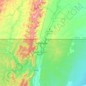
Name: Yacuiba topographic map, elevation, terrain.
Location: Yacuiba, Yacuíba, Gran Chaco, Tarija, Bolivia (-22.17368 -63.83811 -21.85368 -63.51811)
Average elevation: 2,306 ft
Minimum elevation: 1,381 ft
Maximum elevation: 4,715 ft
Make a donation
Gear up for your next adventure:
As an Amazon Associate, this site earns from qualifying purchases at no extra cost to you.
Other topographic maps
Click on a map to view its topography, its elevation and its terrain.