Geolocate

Govilon topographic map

Click on the map to display elevation.

About this map

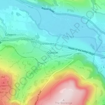
Name: Govilon topographic map, elevation, terrain.

Location: Govilon, Monmouthshire, Wales, NP7 9RB, United Kingdom (51.79874 -3.08665 51.83874 -3.04665)

Average elevation: 610 ft

Minimum elevation: 144 ft

Maximum elevation: 1,818 ft

Other topographic maps

Click on a map to view its topography, its elevation and its terrain.

Wye Valley

United Kingdom > Wales > Monmouthshire

Average elevation: 548 ft

Chepstow Castle

United Kingdom > Wales > Monmouthshire > Chepstow

Average elevation: 174 ft

Penallt

United Kingdom > Wales > Monmouthshire

Average elevation: 571 ft

Crucorney

United Kingdom > Wales > Monmouthshire

Average elevation: 974 ft

Blorenge

United Kingdom > Wales > Monmouthshire > Govilon

Average elevation: 1,293 ft

River Monnow

United Kingdom > Wales > Monmouthshire

Average elevation: 564 ft

Llanbadoc

United Kingdom > Wales > Monmouthshire

Average elevation: 256 ft

Raglan Castle

United Kingdom > Wales > Monmouthshire > Raglan

Average elevation: 194 ft

River Monnow

United Kingdom > Wales > Monmouthshire

Average elevation: 564 ft

Gear up for your next adventure:

🪶Camp Gear Gift Set - Perfect gift bundle for outdoor fans
🧭Outdoor Navigation Book - Learn advanced navigation skills
🚑Emergency Bivvies - Heat-reflective sleeping bags for survival situations
🪑Ultralight Camp Chairs - Portable seating for resting after a long day of mapping
🛏️Cold Weather Sleeping Bag - Warm sleeping bag for cold conditions

As an Amazon Associate, this site earns from qualifying purchases at no extra cost to you.