
Make a donation
Gear up for your next adventure:
As an Amazon Associate, this site earns from qualifying purchases at no extra cost to you.
Madaoua topographic map
Click on the map to display elevation.
Make a donation
Gear up for your next adventure:
As an Amazon Associate, this site earns from qualifying purchases at no extra cost to you.
Madaoua
The agricultural town is located in the fertile plain of the Tarka Valley in the Sahel region. The city centre lies at an altitude of 322 m. Madaoua's neighbouring municipalities are Bouza and Karofane in the north, Ourno in the east, Bangui in the south, Sabon-Guida in the southwest, Galma Koudawatché in the west and Azarori in the northwest.
Make a donation
Gear up for your next adventure:
As an Amazon Associate, this site earns from qualifying purchases at no extra cost to you.
About this map
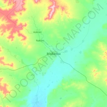
Name: Madaoua topographic map, elevation, terrain.
Location: Madaoua, Tahoua Region, Niger (13.91080 5.79530 14.23080 6.11530)
Average elevation: 1,155 ft
Minimum elevation: 978 ft
Maximum elevation: 1,663 ft
Make a donation
Gear up for your next adventure:
As an Amazon Associate, this site earns from qualifying purchases at no extra cost to you.