
Make a donation
Gear up for your next adventure:
As an Amazon Associate, this site earns from qualifying purchases at no extra cost to you.
Aweil topographic map
Click on the map to display elevation.
Make a donation
Gear up for your next adventure:
As an Amazon Associate, this site earns from qualifying purchases at no extra cost to you.
Aweil
The topography is flat and prone to flooding. However, at an elevation of 425 m (1,394 ft) Aweil is on higher ground than the surrounding plains. The city lies close to the confluence of the Lol River with the Pongo River. The average elevation of the city of Aweil is about 425 metres (1,394 ft) above sea level.
Make a donation
Gear up for your next adventure:
As an Amazon Associate, this site earns from qualifying purchases at no extra cost to you.
About this map
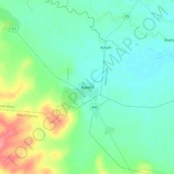
Name: Aweil topographic map, elevation, terrain.
Location: Aweil, Aweil West, Northern Bahr el Ghazal, South Sudan (8.60934 27.23621 8.92934 27.55621)
Average elevation: 1,414 ft
Minimum elevation: 1,368 ft
Maximum elevation: 1,578 ft
Make a donation
Gear up for your next adventure:
As an Amazon Associate, this site earns from qualifying purchases at no extra cost to you.